"Macrochlamis" magnolia ojaiensis Smith, 1991
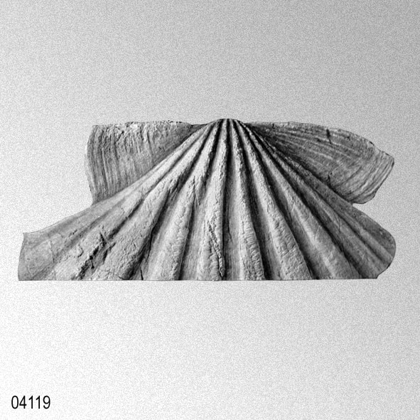
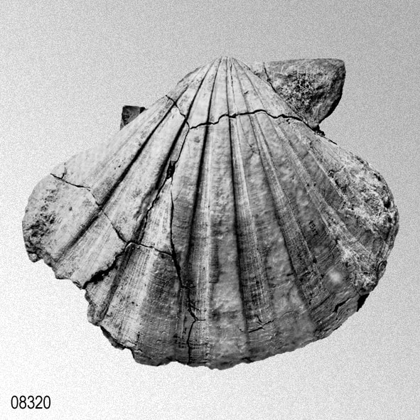
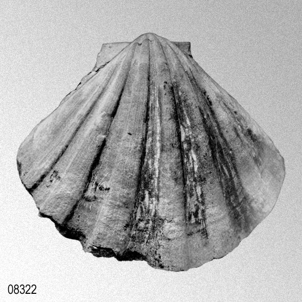
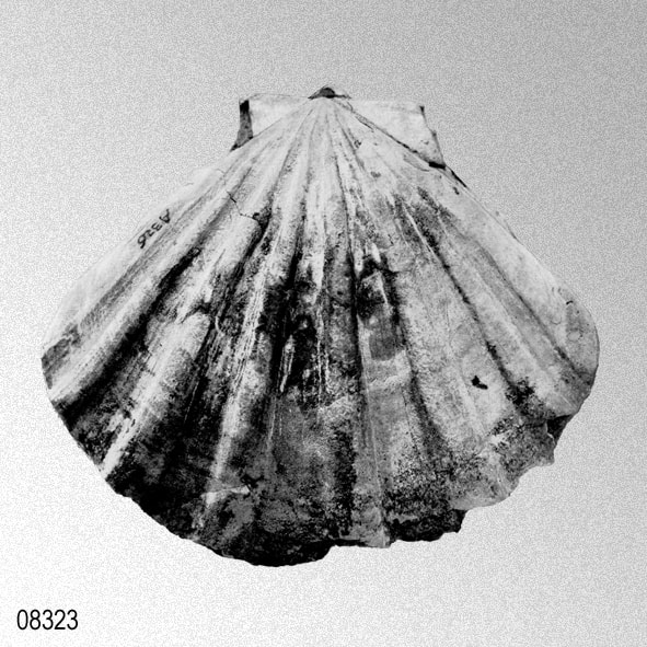
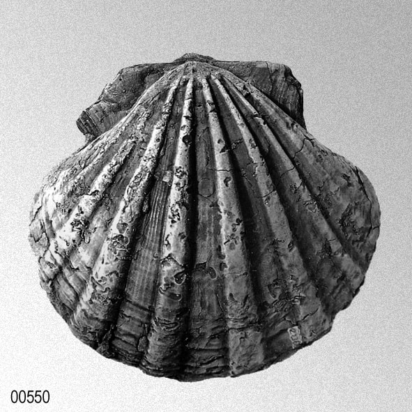
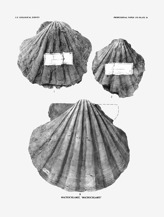
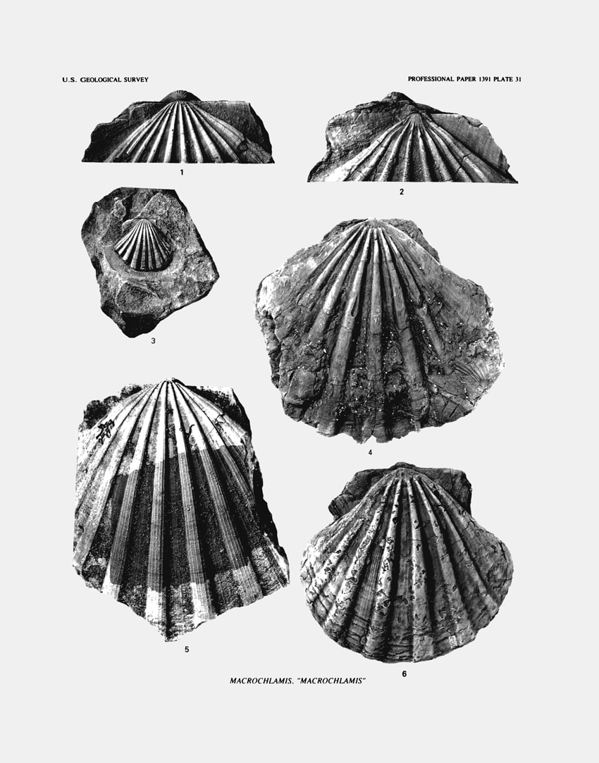
SMITH, J. T. 1991. Cenozoic Giant Pectinids from California and the Tertiary Caribbean Province: Lyropecten, "Macrochlamis", Vertipecten, and Nodipecten species. United States Geological Survey Professional Paper, 1391: v + 1-155, figs. 1-18, pls. 1-38. [p. 74, pl. 29; figs. 1-2; pl. 30, fig. 3; pl. 31; figs. 2-3, 6]
1991 "Macrochlamis" magnolia ojaiensis Smith, 1991
1923 Pecten (Lyropecten) vaughani emigdioensis Wagner & Schilling, 1923
1923 Pecten (Lyropecten) vaughani emigdioensis Wagner & Schilling, 1923
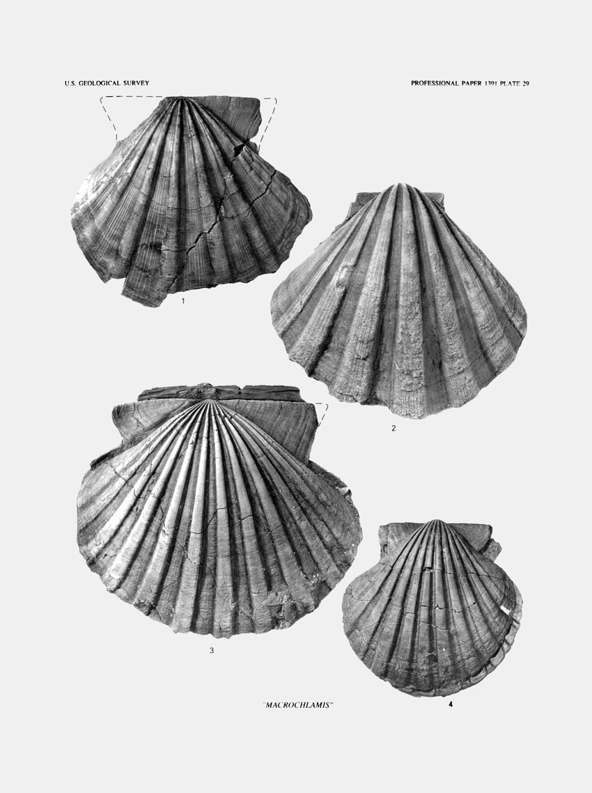
J. T. Smoth, 1991, plates 29-31.
|
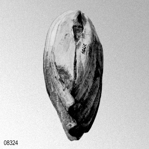
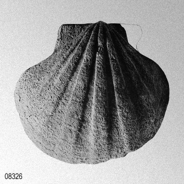
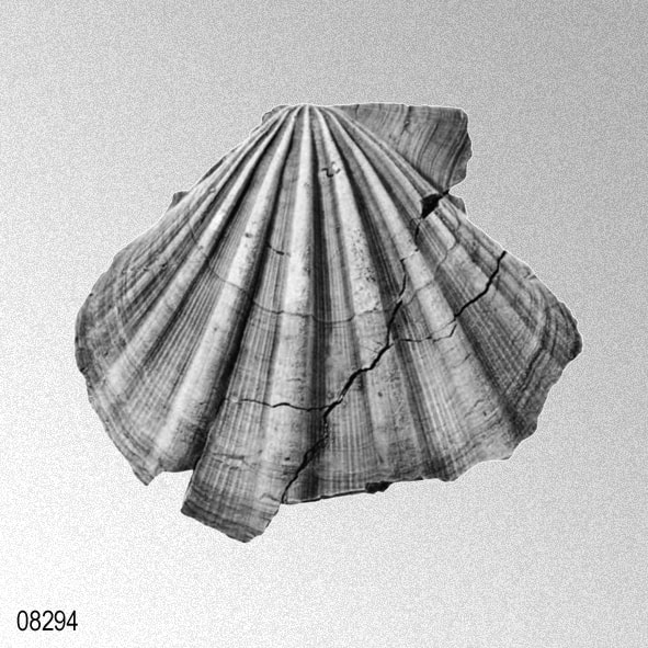
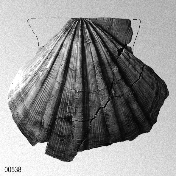
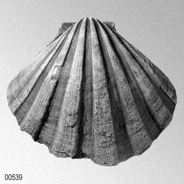
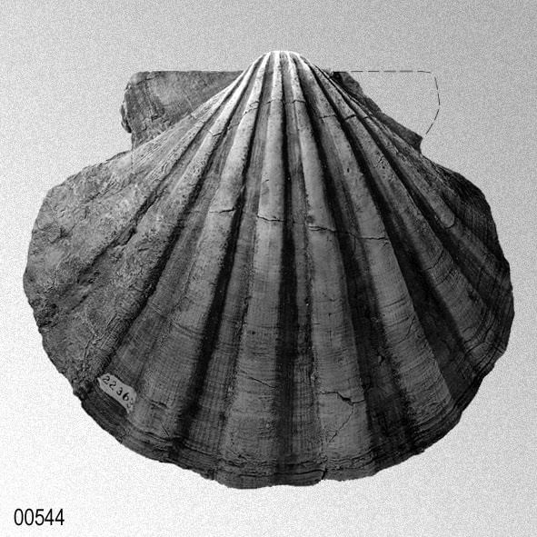
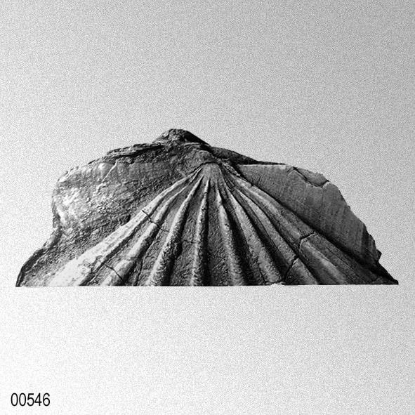
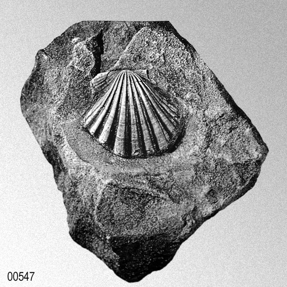
Holotype.— USNM 335004, formerly LSJU accession no. 22366, a double-valved adult 13.2 cm high, 14.5 cm long, is designated as type. It is named for the Ojai Valley, a Chumash Indian name pronounced 6' high, meaning "moon."
Paratype.— UCMP 37383. Type locality.— Ventura County, Calif., Ojai 7½-minute quadrangle "East end of Ojai Valley near the abandoned oil well" according to notes from Stanford Summer Geology, 1931 (field loc. 20-Z, = UCMP D-8792). Vaqueros Formation, upper Oligocene (lower Miocene of many authors). Taxonomic comment.— The "few-ribbed Ojai form" can be separated morphologically and stratigraphically from "M." magnolia, s.s. Pecten emigdioensis Wagner and Schilling, based on a juvenile left valve from the San Emigdio Range, is possibly a juvenile of this taxon, although the name is rejected because it is not certain that the single immature specimen is the same species as the abundant adult "machrochlamids" in the Ojai Valley. Description.— Valves longer than high, convex in adults. Juvenile right valves convex; left valves flat to concave, many with a slight ledge at 1.5 cm height. Right-valve beak projects farther above hinge line than left valve. Auricles large, equal, the posterior auricle higher than the anterior one; auricles smooth except for growth lines and 2-3 obsolete radials near hinge line. Byssal notch shallow. Hinge length greater than three-fourths shell length. Umbonal angle about 90°. Right valves with 6-7 rectangular ribs that are highest and widest in center of shell; lateral ribs progressively narrower and commonly obsolete in adults. Left valves 6-7 ribs, which are narrower than interspaces. Fine macrosculpture of radial costae and concentric growth lines; coarse radial costae rarely preserved in interspaces of a few individuals (loc. USGS 13330). The largest individual studied was incomplete at 14.7 cm high (LSJU accession no. 22367). Variability.— Ribs usually 6-7, 8 in some specimens (UCR loc. 7586). Juveniles may have one rib more than adults. Left-valve umbonal area slightly concave, flat, or normal. Comparative notes.— "Macrochlamis" magnolia ojaiensis has fewer ribs than "M." magnolia, s.s. ; the right-valve beak projects farther above the hinge line. Middle to late Oligocene forms have rib counts intermediate between the two subspecies. In a broader framework, "M." magnolia, s.l. from California may be related to M. toumalii, s.l., M. terebratulaeformis (pl. 30, figs. 1, 2; pl. 31, fig. 4), and European taxa referred to M. subholgeri (Fontannes, 1878) and M. restitutensis (Fontannes, 1881). Shared morphologic characters include shape and size of auricles, juvenile growth forms, and comparable rib counts, profiles, and fine sculpture. Of the two California subspecies, "M." magnolia ojaiensis is closer to European specimens referred here to M. terebratulaeformis (de Serres, 1829). California localities yielding cognate material most like the European specimens include UCR 1154 and UCLA 1311. Geographic distribution and stratigraphic occurrences.— Transverse Ranges, from the Sespe Creek area to the Santa Susana Mountains; present but not common as far north as San Mateo County, south to the San Emigdio Mountains. Very rare in the Santa Monica Mountains, Point Dume quadrangle, south of the Malibu Bowl fault. Also from Pyramid Hill, Kern County, and the eastern Temblor Range. Not from the type locality of the Vaqueros Formation, member E or F as indicated in faunal lists (Thorup, 1942). Specimens that are intermediate in rib count between "M." magnolia s.s. and "M." magnolia ojaiensis come from the Huasna Basin, the western Santa Susana Mountains, and south of the Santa Ynez River in the Los Olivos15-minute quadrangle. Distributions are plotted for comparison with occurrences of "M." magnolia, s.s. on figure 11. The map demonstrates the problem of interpreting paleogeography from species distributions: localities of "M." magnolia, s.l. alone suggest simple basins, but zoogeographic data from larger faunal assemblages demonstrate 150-200 mi of lateral offset along the San Andreas fault since the Oligocene (Addicott, 1968). This amount of displacement is also supported by data from studies of sedimentary basins, Tertiary volcanic rocks, structural relationships, and geomorphology. 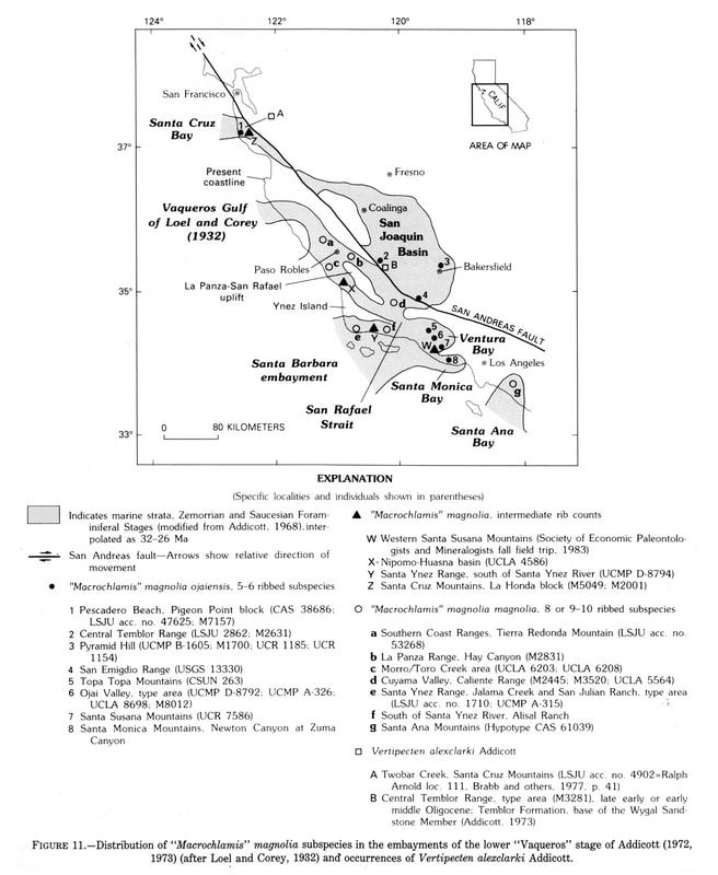
Representative localities for "M." magnolia ojaiensis:
Ojai Valley and east along Oak Ridge, Vaqueros Formation: USGS M8012 = UCMP D-8792; LSJU accession no. 22367,143, 33535; UCLA 1311; UCMP A-326, A-330). Ridgetops on the Alisal Ranch, south of Solvang and the Santa Ynez River, Santa Ynez 7V2-minute quadrangle. Santa Susana Mountains (UCR 7586). Topatopa Mountains, Lion Canyon 7V2-minute quadrangle, with Vertipecten kemensis (CSUN 263). South of Huasna Peak, Nipomo 15-minute quadrangle (UCLA 4586) and in isolated outcrops in the northwestern part of Vaquero Flat (UCLA 4584, 4583 of Hall and Corbato, 1967). Temblor Range, from the lower part of the Temblor Formation, Santos Shale Member, Agua Sandstone Bed in the Packwood Creek 7½-minute quadrangle: LSJU loc. 2862; USGS M2631; at UCR 1269 specimens are intermediate in rib count between "M." magnolia, s.s. and "M." ojaiensis. "Macrochlamis" magnolia ojaiensis forms a biostrome in the basal conglomerate of the Agua Sandstone Bed, where it is found with Vertipecten fragments of a form transitional between V. perrini and V. kernensis. San Emigdio Mountains (UCR 4021; USGS 13330); in the Temblor Formation near Pleito Creek (Nilsen and others, 1973). Material from USGS 13330 (east side of Pleitito Creek) has a hard pebble and sand matrix; specimens match material from Ojai Valley. Santa Monica Mountains, north of the Malibu Coast fault, south of the Malibu Bowl fault, near the junction of Newton Canyon with Zuma Canyon; Vaqueros Formation, undifferentiated, of Yerkes and Campbell (1980a) (field check for this paper). Pyramid Hill, Kern County (UCR 1152, 1154, 1185; UCMP B-6205; USGS M1700), from the Jewett Sand, basal grit. Pescadero Beach, San Mateo County, in the Vaqueros Formation exposed at low tide (GAS 38386; LSJU accession no. 47625). Geologic age.— Late Oligocene. Biostrotigraphic data.— Upper lower "Vaqueros" to lower middle "Vaqueros" Stage. Its highest occurrences are with Vertipecten kernensis (= V. nevadanus auctt.) in the basal grit zone of the Jewett Sand near Pyramid Hill (USGS M-1700) and in the Vaqueros Formation in the Lion Canyon 7½-minute quadrangle (CSUN 263). Paleoecology.— Heavy, articulated shells are found with neritic organisms in coarse conglomerates. In the eastern Temblor Range near Cedar Canyon (USGS M2631), concentrations of "M." magnolia ojaiensis form a biostrome in basal conglomerates of the Agua Sandstone Bed, Santos Shale Member, Temblor Formation.» JUDITH TERRY SMITH, 1991
|